.

Dedicated to the military history and civilization of the Eastern Roman Empire (330 to 1453)


"Time in its irresistible and ceaseless flow carries along on its flood all created things and drowns them in the depths of obscurity."

- - - - Princess Anna Comnena (1083–1153) - Byzantine historian

Sunday, November 25, 2018

The 1st Battle of Yarmouk - Battle for the Middle East


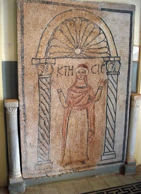
Sassanid Persian Armored Cataphract
(www.radpour.com)

Islam on the March
Battle for the Middle East Part V


Here we are in Part V of the titanic Battle for the Middle East.

In 629 AD the Roman Empire was enjoying a much deserved period of peace after a brutal 26 year long war of all wars with the Persian Empire.  Finally there was peace.  No one in Constantinople had any idea that a fresh invasion from the southern deserts would happen in a matter of months.

Part I  -  In Part I of this series we saw the first military contact between Romans and Muslim Arabs at the Battle of Mota (Mu'tah) in the Roman province of Palaestina Salutaris.  A force of Romans and their Christian Arab allies mauled the invading Muslim army forcing them to return to Medina.

Part II  -  In Part II we saw the Muslims turn their attention to a weakened Persian Empire. Muslims defeated the Persians in a series of battles. The Muslims marched up the Euphrates River through Persian Mesopotamia finally coming within 100 miles of the Roman frontier at Firaz. Firaz was at the outermost edge of the Persian Empire but it still contained an undefeated Persian garrison. There the Persians joined forces with the local Roman garrison and with Christian Arabs to take on the invaders. They were soundly defeated.

Part III  -  In Part III we have the Emperor Heraclius organizing the defense of Palaestina Salutaris.  Muslims made a wide flanking movement of hundreds of miles through waterless deserts to threaten Damascus failed when confronted by Roman armies.  The Romans held their own in Syria and had dug in at the Daraa Gap fortifications in eastern Palestine. But the Romans were defeated in southwest Palestine allowing Muslim forces to fan out reaching as far north as Lydda and Jaffa.


Part IV  -  Battle of Ajnadayn 634. The Romans were dug in at Daraa in Syria and were successfully holding off the invading Muslim army. Emperor Heraclius sent a second army down coastal Palestine with the support of the Roman Navy. The goal was to defeat the smaller Muslim army at Beersheeba and then block the lines of communications to Mecca of the Muslim army at Daraa forcing them to retreat back to Arabia. 


Battle of Babylon (May 634)


Map from The Great Arab Conquests by General Sir John Bagot Glubb


The Romans were not the only target of the invading Muslim armies - the Persian Empire was also ground zero. The Arabs were fighting a war on two fronts.

In December 633 the Muslim General Khalid withdrew half of the Arab army from the Persian front in order to re-enforce the Arab forces facing the Roman Army in Syria.

At this stage the Muslim commanders in Medina may have looked upon Persia as a secondary front because they left a rural Bedouin chief, Al-Muthanna ibn Haritha, in charge of the remaining forces. Whatever his modest background Muthanna was a brave fighter who prepared his smaller force to take on the army of the Persian King of Kings.

The boy king, Yazdegerd III, had but recently assumed the throne. He prepared to signalize his accession by driving away these Arab invaders. Muthanna offered battle near the ruins of ancient Babylon.

The Persians under Hormozd Jadhuyih wanted to test the Muslim forces after Khalid left for the western front. In May, 634 the Persians arrived with an elephant which led the attack. The Arabs were not sure how to deal with this early version of a "tank" attack, and the elephant caused some consternation in the ranks. 

Accompanied by a few fellow tribesmen Muthanna himself attacked and brought down the elephant. Deprived of its help the Persians gave way and the Arabs were left the victors in the battle. The defeated Persians fled the region to the safety of Ctesiphon.

We do not know the numbers of troops involved or the casualties. What we can observe is the rather feeble response of the Persians to a rather weak Arab army. This can only be explained by the years of civil war anarchy inside Persia after their huge defeat by the Romans.

From a greater theater of war point of view the failure of the Persians allowed Arab armies facing the Romans on the Palestine and Syrian fronts to remain in place. A victory by Persia would have forced the shifting of Arab troops back to the Persian front and allow the Romans time to reorganize.

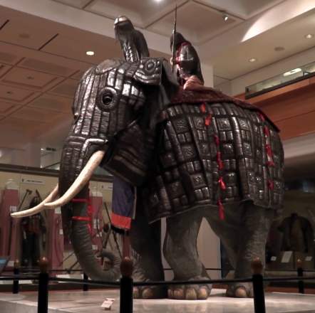
A War Elephant was used as a "tank" by
the Persians against the Arab invaders.

Hassau chieftains in 1941 Chad. The Arabs facing the Romans might have looked much like these horsemen.
(magnumphotos.com)

Prelude to Battle

Personally I break out laughing when I run across so-called "history" books where the authors have not a clue about the Muslim invasions. These clowns treat the Roman loss at Yarmouk in 636 as a simple single battle conducted by a weak Byzantine Empire that could not defend itself.

Nothing could be further from the truth.

The Battle for the Middle East series that I am doing shows years of campaigns and multiple battles by Roman and Persian armies against the Arabs over hundreds and hundreds of square miles.

Up to early 634 the Arabs had totally failed to dislodge and defeat the main Roman Army at the Daraa Gap fortifications (see map below).

Emperor Heraclius sent a second army down coastal Palestine with the support of the Roman Navy. The goal was to defeat the smaller Muslim army at Beersheeba and then block the lines of communications to Mecca of the Muslim army at Daraa forcing them to retreat back to Arabia. 

Instead the Muslims at Daraa sent most of their army on a rapid 200 mile forced march to the south to join with the Beersheeba force and do battle with the Romans at Ajnadayn in July of 634..

The Romans were defeated and their troops were forced to retreat to Damascus or to other walled cities.  It is significant that they were able to retreat. That means the retreat may have been more or less orderly and that the Muslims were in no condition to follow them.

Heraclius himself withdrew from Emesa to the greater safety of Antioch. His strategic counter-offensive was crushed and the troops available to fight off the invasion vastly reduced. 

In 2017 and for the first time in about 1,500 years, a full turma of Roman cavalry, the Roman name for a 30-strong cavalry unit, was brought together to perform some of the manoeuvres that would have been done at the time of Hadrian. The Eastern Roman Cavalry that faced the Arabs inherited the centuries long traditions of the army.
(Followinghadrian.com)

Map from The Great Arab Conquests by General Sir John Bagot Glubb
.
The prepared Roman positions in the Darra Gap were protected on the left by the deep gorges created by the Yarmouk River and on the right by the lava mountains of Jebel Hauran.


1st Battle of Yarmouk (September 634)

The titanic years long, multi-nation Battle for the Middle East drives a historian mad. On the Byzantine side proper histories of events are nearly nonexistent while the "histories" on the Muslim side were written long after events by those who knew nothing about what happened first hand.

We can accept aspects of the Muslim stories as oral traditions of events passed on like tales told around the campfire. But a better guide is to follow troop movements and battles. A military historian can read between the lines to try and put together reasons for events.

After the Campaign of Ajnadayn in July 634 the victorious Arabs in coastal Palestine did not move north.  Instead they retraced their steps and returned to their old positions to the east at the Daraa Gap.

Why?

There can be only one real reason why the Muslims did not march north. That choice of retreating from the battlefield of their victory says a lot about the weakness of the Arabs and their fears of the remaining Roman Army. We can deduce that significant Roman forces may have still been active in the coastal zone as well as large garrisons of Romans behind the walls of cities throughout the region.

That brings us to the the Daraa Gap and the 1st Battle of Yarmouk.

We know for a fact that up to early 634 the Arabs had totally failed to dislodge and defeat the main Roman Army at the Daraa Gap fortifications. But now we see the Muslims deliberately seeking battle at this same location where they failed before.

Again why?

It is logical to conclude for the Muslims to fight again at this spot that circumstances had changed.

We do not know what changed, but we can speculate. An obvious conclusion comes from why the Muslims did not march north along the coast.

  • Perhaps they stripped the coastal zone of Muslim troops and sent them northeast to the Daraa Gap in a final effort to dislodge the Romans from their prepared positions. 
  • Another possibility is additional reinforcements from Arabia could have arrived.
  • Or a combination of both.

We know the Persian front had already seen the extra Muslim forces sent west. So help would not have come from that direction.

The prepared Roman positions in the Daraa Gap were protected on the left by the deep gorges created by the Yarmouk River above and on the right by the lava mountains of Jebel Hauran.

With no records of troops coming from Arabia I will assume the Muslim General Khalid ibn al-Walid was reinforced by troops from coastal Palestine. Khalid's army at Daraa might have grown to upwards of 15,000 men.

The Roman Army at Daraa must have been sizable to start with because they had defeated all Muslim attempts to capture the position. All numbers are a guess but the Romans might have had 7,000 or more men holding the fortifications.

On Easter 634 at the Battle of Marj Rahit we saw Roman troops and their Ghassanid Christian Arab allies fielded about 8,000 men to defeat the Muslims in Syria. These "extra" troops had not been at Daraa but were close by and available to reinforce the Daraa fortifications or protect the flanks.  That could push up Roman forces in the area closer to 15,000.

There is also the possibility that some retreating Roman units from the defeat at Ajnadayn may have joined with the garrison at Daraa.

No matter how you count, both sides were at full strength and ready to fight.

Another factor is morale. The Roman defeat at Ajnadayn may have depressed both the officers and the rank and file while that of the Muslims had been correspondingly exalted. 

Starting in August the fighting became more active in the Daraa Gap.

Near the end of August or early September the skirmishing evolved into a full battle. Historian Lieutenant-General Sir John Bagot Glubb says the battle lasted for several days.

Once again we are witness to what had to have been a massive struggle and we have no details at all of what happened.

General Glubb previously wrote of the Roman's entrenched camp near Daraa in the gap between the Yarmouk's gorge and the lava beds. The Arabs would sometimes skirmish in front of this camp and then withdraw, but their lack of military science made it difficult for them to assault it.  How many other fortified Roman strong points there were we do not know.

The facts show that when the Muslims returned the Romans did not cut and run. They stood in place and fought for days. That says a lot about the level of training and discipline of the Roman Army.

During the height of the battle a letter came from Arabia relieving Khalid of his command. That information was kept from him until victory was achieved. 

The details of what happened are a mystery. We can imagine days of Muslim attacks on the entrenched Roman positions. Cavalry charges and counter charges. Attempts by the Muslims to work around the Roman positions to get to the rear.

The summer August desert heat may have been a factor. Many of the Roman troops would have come from the cooler climates of Anatolia or the Balkans. Fighting in armor in the summer sun might have worked against them. The Muslims would have been more lightly clad and used to the desert heat.

By the end of August or early September the Muslims appeared to have either broken into the fortifications or the Romans felt they were losing control of the battle. In any case the Romans began to withdraw and retreat north.

Afterwords

Daraa had fallen. The door to Syria had been forced open.

It should be noted that Muslim historians did not boast of this as a great victory. There is no flowery language of the slaughter of the Romans or prisoners taken.

As for the Romans they appear to have deliberately decided to pull out. Their army retreated north to Damascus and perhaps points beyond.

The Muslims may have opened the door to Syria, but victory was a long way off. There were Roman armies operating all over Palestine and Syria and holding walled cities such as Jerusalem, Caesarea, Tyre, Tripoli and Damascus. The coastal cities could also be resupplied and reinforced by the Roman Navy.

The Emperor Heraclius had not given up. More troops were being raised for yet another counter attack.

See you later for Part VI.

Legionnaires vs Bedouins

This clip is from the 1977 movie March or Die.  A detachment of the French Foreign Legion fights in Morocco with Bedouin revolutionaries.

The battle scene naturally features mostly modern weapons. But the battle gives you the flavor of what it must have been like in fight between the Romans and Arabs.

No modern soldier can begin to imagine standing in ranks shoulder-to-shoulder with 5,000 fellow Romans armed with but a shield, sword and spear. You stand there in armor in the desert heat waiting to receive a cavalry-infantry charge by 7,000 to 10,000 invading Arab soldiers that will result in vicious, slashing hand-to-hand combat.


Limitanei static frontier guard troops existed
through the Persian Wars and the Arab Conquest.

kk
The Battle for the Middle East
.
Read More:
.
Part I - Roman Empire vs Islam - First Contact
.
Part II - A Persian-Roman Army Fights Muslim Invaders
kk

Part III - Muslims Invade Roman Palestine
m
.
Part IV - Battle of Ajnadayn


(Battle of Babylon)      (Great Arab conquests)

Friday, November 2, 2018

The Fortress of Apollonia in Cyrenaica


The Byzantine Palace in Apollonia with the Eastern Basilica in the background. The previous use was as a Roman military commander's house.

Apollonia - African Military Base

  • As the capital of the Roman province of Libya Superior, the walled port of Apollonia would have been a military hub for the region. The army would keep the peace against inland tribal raiders while the navy would drop in for supplies while on patrol.


Apollonia in Cyrenaica (modern Libya) was founded by Greek colonists and became a significant commercial center in the southern Mediterranean. It served as the harbor of Cyrene, 20 km (12 mi) to the southwest.
An earthquake damaged the city in 365, but it survived, although many ancient buildings were destroyed. Nevertheless, Apollonia became more important than it had ever been, because in the fifth century, the interior was abandoned to the Libyan Laguatan nomads.
The port remained one of the last bases of Byzantine troops during the Muslim invasions.  There were several new building projects, like the easterncentral, and western basilicas.
The town, refortified during the Ananeosis ("renewal") but in the end conquered by the Arabs, was abandoned in the Middle Ages.
Apollonia became autonomous from Cyrene at latest by the time the area came within the power of Rome, when it was one of the five cities of the Libyan Pentapolis, growing in power until, in the 6th century A.D., it became the capital of the Roman province of Libya Superior or Libya Pentapolitana. 
The city became known as Sozusa, which explains the modern name of Marsa Susa or Susa, which grew up long after the cessation of urban life in the ancient city after the Arab invasion of AD 643.
The early foundation levels of the city of Apollonia are below sea level due to submergence in earthquakes, while the upper strata of the later Byzantine Christian periods are several meters above sea level, built on the accumulated deposits of previous periods.
The Palace was last used as the Byzantine Duke's Palace and contains over 100 rooms. The previous use was as a Roman military commander's house.
The well-preserved Greek theater stands facing the sea outside the old city walls. The cavea has 28 seat levels.

Apollonia was founded as the port of Cyrene. In case of an emergency, like the Arab invasions in the late 600s, the walls had to be defended. The walls of Apollonia, therefore, do not date back to the oldest stage of occupation, but were built in the Hellenistic Age. They are very well preserved, especially in the southeast.

Gate going to the central court of the palace.

The Palace of Apollonia

Apollonia was made capital of a newly created province, Libya Superior, by the emperor Diocletian (r.284-305). It was renamed Sosouza ("savioress"), probably after a goddess who was venerated here (Isis?). The military leader of the region, the dux, built his palace in the city, and rebuilt the original wall from the third century BCE, which was next to it.

The photo above shows one of the gates that gave access to the central court. As you can see, a cross was cut into the stone over this door: a memory of the Christianization of the Roman empire during the reign of Constantine the Great (r.306-337) and his son Constantius II (r.337-361). 

The palace once had two stories, but only the rooms on the ground floor - where the governor received his guests - remain. There were two large villas near this monument, which were probably used as an annex to the palace.

Apollonia became especially important in the fifth century, when the interior was abandoned to the Laguatan nomads (Synesius of Cyrene describes these disastrous years in his Catastasis). The port remained one of the last bases of the Byzantine troops and the palace of the dux must have been one of the most important military buildings in the Cyrenaica.

According to Procopius, the Byzantine Empress Theodora spent several years in the palace of Apollonia, as mistress of a governor named Hecebolus. Later, she married Justinian (527-565) and became one of the most powerful women from Antiquity.


Reconstruction of the port of Apollonia
(Livius)

The port of Apollonia was built around two or three natural harbors, which have disappeared beneath the waves in 365 CE, when a giant tidal wave destroyed the coast of northern Africa. It seems that the inner harbor - which was surrounded by quays and store houses - was used for warships, and the outer harbor for merchant ships. 

In the eastern part were a large mole and a lighthouse. This mole and the outer harbor were built by the Romans; the inner harbor appears to be Greek.

In 1987, a small ship (thirteen meters long) was discovered; the remains are now in the museum of Sousa.


Port facilities
Apollonia was an important port for commerce in North Africa. 

Apollonia, bathhouse and port
The Bathhouse

The Bathhouse was built during the reign of the emperor Hadrian (117-138). Probably, the court that is the core of the bathhouse is the peristyle of an older house: many Greek houses from the Hellenistic age were built around a garden-court (cf. the Villa of the Four Seasons Mosaic in Ptolemais and the Villa of Jason Magnus in Cyrene).

Today, you can still see the courtyard, which was once surrounded with Corinthian columns, and must have been used by people doing their athletic exercises (palaestra). Also visible are the real baths, which were still in use in the fourth century. The original entrance must have been to the north, where the main road of Apollonia used to be until, in 365, a large tidal wave destroyed much of the city. After that, the Baths were abandoned; it seems that people were living in the old monument.


Defensive city walls of Apollonia

Military and Civil Administration

Egypt was formed into a separate diocese in about 381. According to the Notitia Dignitatum, which for the Eastern part of the Empire dates to ca. 401, the diocese came under a vicarius of the praetorian prefecture of the East, with the title of praefectus augustalis, and included six provinces:
  • Aegyptus (western Nile delta), originally established in the early 4th century as Aegyptus Iovia, under a praeses
  • Augustamnica (eastern Nile delta), originally established in the early 4th century as Aegyptus Herculia, under a corrector
  • Arcadia (central), established ca. 397 and having previously briefly listed in the 320s as Aegyptus Mercuria, under a praeses
  • Thebais (southern), under a praeses
  • Libya Inferior or Libya Sicca, under a praeses
  • Libya Superior or Pentapolis, under a praeses

6th Century Eastern Roman Soldier

Parallel to the civil administration,
the Roman army in Egypt had been placed under a single general and military governor styled dux (dux Aegypti et Thebaidos utrarumque Libyarum) in the Tetrarchy
Shortly after the creation of Egypt as a separate diocese (between 384 and 391), the post evolved into the comes limitis Aegypti, who was directly responsible for Lower Egypt, while the subordinate dux Thebaidis was in charge of Upper Egypt (Thebais). 
In the middle of the 5th century, however, the latter was also promoted to the rank of comes (comes Thebaici limitis). The two officers were responsible for the limitanei (border garrison) troops stationed in the province, while until the time of Anastasius I the comitatenses field army came under the command of the magister militum per Orientem, and the palatini (guards) under the two magistri militum praesentales in Constantinople.
The comes limitis Aegypti enjoyed great power and influence in the diocese, rivalling that of the praefectus augustalis himself. From the 5th century, the comes is attested as exercising some civilian duties as well, and from 470 on, the offices of comes and praefectus augustalis were sometimes combined in a single person.
This tendency to unite civil and military authority was formalized by Justinian I in his 539 reform of Egyptian administration. The diocese was effectively abolished, and regional ducates established, where the presiding dux et augustalis was placed above the combined civil and military authority:
  • dux et augustalis Aegypti, controlling Aegyptus I and Aegyptus II
  • dux et augustalis Thebaidis, controlling Thebais superior and Thebais inferior
  • Augustamnica I and Augustamnica II were likewise probably — the relevant portion of the edict is defective — were placed under a single dux et augustalis
  • in the two Libyan provinces, the civil governors were subordinated to the respective dux
  • Arcadia remained under its praeses, probably subordinated to the dux et augustalis Thebaidos, and a dux et augustalis Arcadiae does not appear until after the Persian occupation of 619–629.


Apollonia, central basilica, baptistery

Apollonia, central basilica

Apollonia, east basilica, mosaics

Apollonia in Cyrenaica (eastern Libya) after Alexander


From Megas Alexandros

In 322 BC, the year after Alexander’s death, Ptolemy I who had established himself as ruler of Egypt conquered five Libyan cities. They are collectively known as thePentapolis and include beside Cyrene, the cities of Apollonia, Ptolemais or Barca,Arsinoe or Taucheira (modern Tocra) and Euesperides or Berenice (near modern Benghazi). In those days, Cyrenaica was part of greater Egypt and often simply assimilated to Egypt itself. 

The region was very fertile and produced wheat and barley, as well as olive oil and wine; the orchards in turn were filled with fig and apple-trees; sheep and cattle roamed widely; and above all, this was the only place in the world where silphium grew, a natural medicine, a contraceptive and aphrodisiac.


In an earlier post, I already wrote about Cyrene (see: Cyrene, founded by the Greeks), so this time I’ll concentrate onApollonia, now renamed Susa in today’s eastern Libya, the most obvious choice since it was the harbor for majestic Cyrene only some twenty kilometers further inland.

Apollonia was founded by Greek colonists as early as the 7th century BC and during the fourth century BC the harbor facilities were widely improved, sheltering the berths against the strong northern winds. On the west side a new inland port was constructed, protected by two towers while on the most eastern island a lighthouse was installed. It was only in the first century BC that Apollonia became a city in its own right. Not for long, however, since upon Ptolemy III’s death in 96 BC the entirePentapolis, including Cyrene and Apollonia was bequeathed to the Romans who just moved a step closer to Egypt itself …

Apollonia was part of The Diocese of Egypt which was a diocese of the later Roman Empire (from 395 the Eastern Roman Empire), incorporating the provinces of Egypt and Cyrenaica. Its capital was at Alexandria, and its governor had the unique title of praefectus augustalis ("Augustal Prefect", of the rank vir spectabilis; previously the governor of the imperial 'crown domain' province Egypt) instead of the ordinary vicarius. The diocese was initially part of the Diocese of the East, but in ca. 380, it became a separate entity, which lasted until its territories were finally overrun by the Muslim conquest of Egypt in the 640s.


Today’s visitor to Apollonia will only find half of the antique city as the other half lies under water. Northern Africa has suffered badly from a devastating earthquake that occurred in 365 AD, causing the entire coastline to drop by four meters. The phenomena is clearly visible here in Apollonia where the old harbor is entirely drowned and the three off-shore islands is all that remains of the northern pier. This explains why the city doesn’t have the appeal of a harbor, and certainly not one to serve a city as important as Cyrene. Apparently shipwrecks from the fourth century BC have been located in the antique harbor where French archeologists were diving during my visit in 2010. I hate to think about what has happened since.

Anyway, Apollonia’s remains are mainly Byzantine, with three Basilicas: the western Basilica with three naves; the central Basilica with five naves; and to the far end the eastern Basilica, the largest, from the 6th century with an exceptional Baptistery because it counts six steps instead of the normal three. My local guide tells me that in the Byzantine era the purpose of this Baptistery was not to baptize people in order to convert them but to receive forgiveness for their sins. One submersion would cleanse the believer from small sins, but for more serious offenses five or six submersions would be required. I never heard of this theory but it may be a logical explanation for the great number of baptisteries in these churches.

Next to the central Basilica are the remains of a Roman Bath, whose lay-out, except for the entrance gate, is rather confusing. That is no surprise when you think how the Byzantines liked to re-model Roman buildings or re-use their stones elsewhere.

Alongside the Byzantine city wall and approximately across from the Roman Baths, lies the Palace of the Dux, the Byzantine governor Hekobolius from the 6th century, i.e. the time when Apollonia was the capital of the Pentapolis. The palace itself has not much to offer but the story that goes with it is rather interesting. For nearly six years, this Hekobolius kept an extremely good looking mistress called Theodora. One day she happened to be dancing in Constantinople for Emperor Justinian who fell in love head over heels and married her soon after. This is how Empress Theodora arrived at the imperial court where she lived happily ever after … Well, this marriage lasted about twenty years and Theodora died before Justinian, on 28 June 548.

There are more remains of Apollonia that have not yet been excavated, including the Acropolis at the far end of the site. Outside the city-wall lies the inevitable Roman theater (although built on an earlier Greek one) that now lies near the shoreline. According to an inscription found near the podium, it was built in 92 AD during the reign of Emperor Diocletian. This is the best preserved theater of theCyrenaica in spite being used as a quarry by the Byzantines.

A last glance over Apollonia makes me realize that the restored columns of the different Basilicas are the most notable features, but that is primarily because of their texture. All these columns are made of cipolin marble, imported from the islandof Euboea before the coast of easternGreeceCipolin is the Italian name for onions and is used to describe this kind of marble which, like onion skins, appears in green-greyish streaks – a very appropriate name, I must say.

Walking back along the coastline, my attention is drawn towards four large round pits carved in the rock. These pits were used to marinate fish in order to make the famous garum or fish paste, a delicacy for the Romans. How interesting!

The well-preserved Greek theater stands facing the sea outside the old city walls. The cavea has 28 seat levels.

Byzantine Church in Apollonia by the coast.

The Goddess Ktisis
The personification of generosity and donation, of Libyan Isis: the Goddess of Agriculture.

(Apollonia (Susa) Museum)


(Apollonia)      (Diocese of Egypt)      (temehu)      (makedonia-alexandros)

(Google books)     (apollonia-photos)      (apollonia-baths)      (Livius.org Libya)