.

Dedicated to the military history and civilization of the Eastern Roman Empire (330 to 1453)


"Time in its irresistible and ceaseless flow carries along on its flood all created things and drowns them in the depths of obscurity."

- - - - Princess Anna Comnena (1083–1153) - Byzantine historian

Friday, January 11, 2013

Harput Castle - Roman / Byzantine Fortress


The Castle of Harput
The isolated rock upon which a castle was later built, has been a
fortified site since the 9th century BC. 


The Roman and Byzantine Fortress of Harput


The Castle of Harput is located at the town of Elâzığ (Turkish pronunciation: [eˈlazɯː]; Armenian: Խարբերդ; Kh'arberd/Harput, Kurdish: Elezîz/Xarpêt , Syriac: ܟܪܦܘܬ; Kharpūṭ/Ḥarfūṭ).

Elazig is a city in Eastern Anatolia, Turkey and the administrative center of Elâzığ Province.

The city of Elâzığ was founded among the skirts of the hill on which the historical Harput Castle was constructed. According to the present historical sources, the most ancient inhabitants of Harput was the Hurrian nation who settled in these parts in c2000 B.C.

Harput, and its surrounding region was part of the kingdom of Urartu at the period of its maximum extension.


The ancient town and citadel called Kharput (Kharpert), which means "rocky fortress" in Armenian, was built by the first Armenian kings about five kilometers from modern Elâzığ.

However, very little written material about this city reached our day. It is possible that Harput stands on or is near the site of Carcathio-certa in Sophene, reached by Corbulo in A.D. 65. The early Muslim geographers knew it as Hisn Ziyad, but the Armenian name, Khartabirt or Kharbirt, whence Kharput and Harput, was generally adopted in time.

The isolated rock, upon which a castle was built later on, has been a fortified site since the 9th century BC.

A strong point like Harput would have been part of both the Roman and Byzantine defensive systems.  The castle exists.  You can see it for yourself.  But I can find near zero information about it.

There are so many questions about Byzantium and its wars that are lost to history.  Unfortunately Procopius of Caesarea (500 – c. AD 565) was the last, and almost only, real historian for the eastern empire.

Eastern Anatolia would have seen many huge military campaigns from Roman to Byzantine times.  This area saw multiple wars with the Persian Empire, Arabs and Turks.  A military strongpoint like Harput would have been involved in defense against those invasions.  When captured the castle would then have become an occupied strong point for the enemies of Rome.  There is a story to be told, but we will never know it.

After the 1071 Battle of Manzikert the region was occupied by Turkish tribes in 1085 and Roman troops in the area were withdrawn to defend the cities closer to the center of Anatolia, the coastal zones and Constantinople. 

The Romans left after 900 years never to return.  The eastern military themes permanently became Muslim and Turkish.


Harput - Over 900 years of Roman Rule
The Roman Empire had control of the Anatolia area around Harput for
about 900 years.  There were endless battles and invasions, but there is zero
information about the castle and its military history.  


In later years William of Tyre wrote that Joscelin I, Count of Edessa (Jocelyn) of Courtenay, and King Baldwin II of Jerusalem were prisoners of the Amir Balak in Kharput's castle and that they were rescued by their Armenian allies. William of Tyre calls the place Quart Piert or Pierre.

The Çubukoğulları, Artuqids and Ottomans ruled in the region..

Harput became part of a small emirate ruled by the Cubuko who were vassals of the Sultanate of Rum; later on the town was occupied by the Artukids, who were based in Mardin and Diyarbakir; Harput was ruled by a separate branch of the Artukids and during this period, the town flourished and its main monuments were built.

In 1234 Harput was annexed by the Sultans of Rum, but in 1243 the Mongol invasion weakened their power and the town was eventually included in Dulgadir, an emirate based in Maras.

In 1465 Harput fell to Uzun Hasan, leader of the Ak Koyunlu (White Sheep federation), Turkmen tribes to whom Timur had assigned the region of Diyarbakir; the Ak Koyunlu came in contact with the Ottomans and they tried in vain to prevent the (last) Byzantine Empire of Trebizond from falling into Ottoman hands; Uzun Hasan established relations with the Republic of Venice in order to contain the expansion of their common enemy.


View of the fortress


The Persian Empire
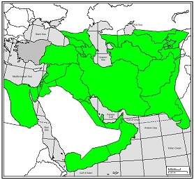
The Persian Sassanid Empire at its greatest extent ca. 620 AD.
.
Harput Castle would have been at the center of many great wars. In the early 600s the Persians conquered Roman provinces from Armenian to Palestine to Egypt.  The Roman Emperor Heraclius fought a devastating war of re-conquest over the Harput area.  But the written military history for the fortress is almost non-existent.
.
Mountains of books in excruciating detail have been written about the totally insignificant American Battle of the Little Big Horn.  But information about the great invasions and battles with the Persians, Slavs, Arabs and Turks often does not exist.  We can only guess at the at the endless acts of heroism and hand to hand combat that took place but are lost to history. 


In 1473, at the battle of Otluk Beli, Sultan Mehmet II led his army to a great victory against the Ak Koyunlu: the battle showed that the Ottomans had an edge on their eastern enemies: they used cannon and rifles whereas Uzun Hasan mainly relied on light cavalry.

Harput remained however in possession of the Ak Koyunlu; in 1507 it was occupied by the Safavids, who ruled over Persia from 1502 to 1722; their control of the town lasted only until 1516 when the Ottomans annexed Harput and the whole region; this occurred after the 1514 battle of Caldiran, in which Ottoman rifles and cannon exterminated the Safavid cavalry. Ak Koyunlu and Safavids regarded the use of cannon and rifles as dishonourable behaviour for a warrior.

Harput housed a large Armenian community who lived at the foot of the fortress; in the region several villages were inhabited almost entirely by Armenians; relations with the Muslim population were relatively good, because the Ottoman system of millet (religious community) granted the Armenians a certain degree of self government.

The Armenians had no reason to support the Safavids, the only enemy the Ottomans had in the east, and they were loyal to the Sultan.

(Elâzığ, Turkey)          (romeartlover.tripod.com)


Wednesday, January 2, 2013

The Byzantine Fortress of Dara


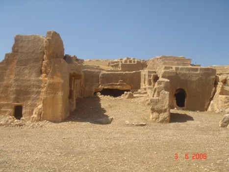
Dara, Necropolis
Dara or Daras was an important East Roman fortress city in Northern Mesopotamia on the border with the Sassanid Empire. Because of its great strategic importance, it featured prominently in the Roman-Persian conflicts of the 6th century, with the famous Battle of Dara taking place before its walls in 530. Today the Turkish village of Oğuz, a few kilometers North of the Syrian border, occupies its location.

The Eastern Roman Fortress of Dara


Dara or Daras was an important East Roman fortress city in northern Mesopotamia on the border with the Sassanid Empire. Because of its great strategic importance, it featured prominently in the Roman-Persian conflicts of the 6th century, with the famous Battle of Dara taking place before its walls in 530. Today the Turkish village of Oğuz, Mardin Province, occupies its location.

Dara Founded by Emperor Anastasius

During the Anastasian War in 502–506, the Roman armies fared badly against the Sassanid Persians. According to the Syriac Chronicle of Zacharias of Mytilene, the Roman generals blamed their difficulties on the lack of a strong base in the area, as opposed to the Persians, who held the great city of Nisibis (which until its cession in 363 had served the same purpose for the Romans).

Flavius Anastasius Augustus
Emperor 491 to 518

Therefore, in 505, while the Persian King Kavadh I was distracted in the East, Emperor Anastasius I decided to rebuild the village of Dara, only 18 kilometres westwards from Nisibis and just 5 km from the actual border with Persia, to be "a refuge for the army in which they might rest, and for the preparation of weapons, and to guard the country of the Arabs from the inroads of the Persians and Saracens".

Masons and workers from all over Mesopotamia were gathered and worked with great haste. The new city was built on three hills, on the highest of which stood the citadel, and endowed with great storehouses, a public bath, and water cisterns.

It took the name Anastasiopolis and became the seat of the Roman dux Mesopotamiae.


Reconstruction by Justinian

According to Procopius, the hasty construction of the original walls resulted in poor quality, and the severe weather conditions of the region exacerbated the problem, ruining some sections. Thus Emperor Justinian I was compelled to undertake extensive repairs to the city, afterwards renaming it Iustiniana Nova. The walls were rebuilt and the inner wall raised by a new storey, doubling its height to about 60 feet (20 m). The towers were strengthened and raised to three stories (ca. 100 feet) high, and a moat dug out and filled with water.
Dara is in Mardin Province, Turkey.

Justinian's engineers also diverted the nearby river Cordes towards the city by digging a canal. The river now flowed through the city, ensuring ample water supply.

At the same time, by means of diverting its flow to an underground channel which exited 40 miles (64 km) to the north, the garrison was able to deny water to a besieging enemy, a fact which saved the city on several occasions. To avert the danger of flooding, which had already once wrecked large parts of the city, an elaborate arch dam was built to contain it, one of the earliest known of its kind. In addition, barracks were built for the garrison, and two new churches were constructed, the "Great Church", and one dedicated to St Bartholomew.

Later history

The city was later besieged and captured by the Persians in 573-574, but was returned to the Romans by Khosrau II after the Roman-Persian treaty in 590. It was taken again by Khosrau in 604-05 after a nine-month siege, restored again to the Roman Empire by Heraclius, until it was finally captured in 639 by the Arabs. After this the city lost its military significance, declined and was eventually abandoned.


The Buildings of Justinian
By Procopius of Caesarea

Book II  -  In Book II Procopius below writes about the fortifications and cities on the Persian frontier


All the new churches which the Emperor Justinian built both in Constantinople and in its suburbs, and all those which, having been ruined by the passage of time, he restored, as well as all the other buildings which he erected here, have been described in the preceding Book.  From this point we must proceed to the defences with which he surrounded the farthest limits of the territory of the Romans.

Here indeed my narrative will be constrained to halt painfully and to labour with an impossible subject.  For it is not the pyramids which we are about to describe, those celebrated monuments of the rulers of Egypt, on which labour was expended for a useless show, but rather all the fortifications whereby this Emperor preserved the Empire, walling it about and frustrating the attacks of the barbarians on the Romans. And it seems to me not amiss to start from the Persian frontier.

When the Persians retired from the territory of the Romans, selling to them the city of Amida, as I have related in the Books on the Wars, the Emperor Anastasius selected a hitherto insignificant village close to the Persian boundary, Daras by name, and urgently set about enclosing it with a wall and making it into a city which should serve as a bulwark against the enemy. 

But since it was forbidden in the treaty which the Emperor Theodosius once concluded with the Persian nation, that either party should construct any new fortress on his own land where it bordered on the boundaries of the other nation, the Persians, citing the terms of the peace, tried with all their might to obstruct the work, though they were hard pressed by being involved in a war with the Huns.


The city walls and tower

So the Romans, observing that they were for this reason unprepared, pressed on the work of building all more keenly, being anxious to get ahead of the enemy before they should finish their struggle with the Huns and come against them.  Consequently, being fearful by reason of suspicion of the enemy, and continually expecting their attacks, they did not carry out the building with care, since the haste inspired by their extreme eagerness detracted from the stability of their work.  For stability is never likely to keep company with speed, nor is accuracy wont to follow swiftness. 

They therefore carried out the construction of the circuit-wall in great haste, not having made it fit to withstand the enemy, but raising it only to such a height as was barely necessary; indeed they did not even lay the stones themselves carefully, or fit them together as they should, or bind them properly at the joints with mortar.  So within a short time, since the towers could not in any way withstand the snows and the heat of the sun because of their faulty construction, it came about that the most of them fell into ruin. So were the earlier walls built at the city of Daras.


The engineers of Emperor Justinian diverted the river Cordes and constructed an underground cistern of huge proportions in Dara.


The Emperor Justinian perceived that the Persians, as far as lay in their power, would not permit this outpost of the Romans, which was a menace to them, to stand there, but they would of course assault it with all their might, and would use every device to conduct siege operations on even terms with the city; and that a great number of elephants would come with them, and these would bear wooden towers on their shoulders, under which they would stand, supporting them like foundations; and worse still, that they would be led about wherever the enemy needed them and would bear a fortress which would follow along wherever, according to the judgement of their masters, it should happen to be needed;  and that the enemy would mount these towers and shoot down upon the heads of the Romans inside the city, and attack them from a higher level; that, furthermore they would raise up artificial mounds against them, and would bring up all manner of siege-engines. 
 
And if any misfortune should befall the city of Daras, which was thrown out like an earthwork before the whole Roman Empire and was obviously placed as a threat to the enemy's land, the disaster for us would not stop there, but a great part of the State would be seriously shaken. For these reasons he wished to surround the place with defences in keeping with its practical usefulness.
 
The Roman and Persian Empires at the time of Justinian.
For centuries the armies of Persia and Rome fought wars over the Tigris–Euphrates Rivers area of Mesopotamia.  The Eastern Roman fortress of Dara was meant to provide a strong point and a block to Persian forces. 
 
First of all he rendered the wall (which, as I have said, was very low and therefore very easy for an enemy to assault) both inaccessible and wholly impregnable for an attacking force. For he contracted the original apertures of the battlements by inserting stones and reduced them to very narrow slits, leaving only traces of them in the form of tiny windows, and allowing them to open just enough for a hand to pass through, so that outlets were left through which arrows could be shot against assailants. 
 
Then above these he added to the wall a height of about thirty feet, not building the addition upon the whole thickness of the wall, lest the foundations should be overloaded by the excessive weight which bore upon them, so that the whole work would suffer some irreparable damage, but he enclosed the space at that level with courses of stones on the outside and constructed a colonnaded stoa (stoa) running all around the wall, and he placed the battlements above this portico, so that the wall really had a double roof throughout; and at the towers there were actually three levels for the men who defended the wall and repelled attacks upon it.  For at about the middle of each tower he added a rounded structure (sphairikon schêma) upon which he placed additional battlements, thus making the wall three-storeyed.
 
Then he observed that it had come about that many of the towers, as I have said, had fallen into ruin in a short time, yet it was entirely out of the question to pull them down, since the enemy were constantly in the neighbourhood watching their opportunity and continually scouting to see whether they might not find some part of the defences dismantled at any time. But he hit upon the following plan.  He left these towers in place, and outside each of them he cleverly erected another structure in the form of a rectangle, which was built securely and with every possible care, and thus, by means of a second set of defences, he safely enclosed those parts of the wall which had suffered. 
 
Dara, Necropolis, historical church-cave

 
But one of the towers, called the "Tower of the Guard," he pulled down at a favourable moment and rebuilt so that it was safe, and everywhere he removed the fear which had arisen from the weakness of the circuit-wall.  He also wisely added sufficient height, in due proportion, to the outworks.  And outside these he dug a moat, not in the way in which men are wont to make them, but only for a short distance and in a novel manner; and the reason for this I shall explain.
The greater part of the defences, as it happens, are in general unapproachable for an attacking party, since they do not stand on level ground and offer no favourable opportunity for assault to an approaching force; but they stand along a steep slope of a rough and precipitous character, where it is not possible for a mine to be dug or for any attack to be made.  But on the side which is turned toward south, the soil is deep and soft and consequently easy to mine, so that it makes the city assailable on this side. 

So in that place he dug a crescent-shaped moat, with sufficient breadth and depth and extending to a great distance, and joined either end of this to the outworks and filled it amply with water, rendering it altogether impassable for the enemy; and on its inner side he set up another outwork. On this the Romans take their stand and keep guard in time of siege, freed from anxiety for the circuit-wall and the other outwork which is thrown out before the main wall.  And it happened that between the main wall and the outwork, at the gate which faces toward the village of Ammodius, there lay a great mound of earth, under cover of which the enemy were able to be in large measure unobserved while making mines against the city under the circuit-wall.  This mound he removed from the spot and he cleared up the place thoroughly, and thus frustrated any secret attack on the wall by the enemy.


Thus did he construct these fortifications. He likewise made reservoirs for water both in the space between the circuit-wall and the outworks and also close by the church which is dedicated to the Apostle Bartholomew, situated toward the west.  And a river also flows from a suburb of the city which is two miles distant from it and is called Cordes. On either side of it rise two cliffs which are exceedingly rugged. This river flows down between the heights on either side of it all the way to the city, carried along the bases of the mountains, and for just this reason it cannot be turned aside or tampered with by the enemy; for there is no flat ground where they might be able to turn it from its course.
 
And it is drawn into the city in the following way.  They have constructed a large channel extending out from the circuit-wall, and covered the mouth of the conduit with a great number of the thickest possible iron bars, some upright and some horizontal; and thus they have arranged that the water can enter the city without endangering the fortifications.  In this way the water flows into the city and fills its reservoirs and then is conducted wherever the inhabitants wish, and finally flows out at another part of the city, the opening for its discharge being made like that by which it enters the city.
 
There was a certain Chryses of Alexandria, a skillful master-builder, who served the Emperor in his building operations and built most of the structures erected in the city of Daras and in the rest of the country. . . . . . He also built numerous barracks for the soldiers, in order that they might cause no annoyance whatever to the inhabitants.
 
Underground church
 
The old cisterns
 
Roman cistern in Dara
Originally an East Roman settlement Dara was a strategically important outpost of the Roman Empire and hence fortified by the Emperor Justinian. What makes it an interesting point to visit today is the vast necropolis, housing tombs of kings and families. Only a part rises above ground the rest still awaits excavation.

Justinian’s engineers also accomplished a great feat: they diverted the river Cordes to the city and constructed an underground cistern which takes your breath away because it’s so unexpected.

You descend stone steps, down, down and further down and then looked up at the massive structure which secured the water supply for the city.


(uchicago.edu - Procopius - Buildings)       (Dara - Mesopotamia)       (www.ac-nice.fr)

Wednesday, December 26, 2012

The Harbor of Theodosius


Harbor of Theodosius
Image Harbor of Theodosius
 
The Harbor of Theodosius
  • The harbor was built in the late 4th century during the reign of Theodosius I, and was the city's major point of trade in Late Antiquity. The area was later transformed for agricultural use due to the effects of erosion and silting. In Ottoman times, the area was built over.
  • In November 2005, workers on the Bosphorus Tunnel Project discovered the silted-up remains of the harbour. Excavations produced evidence of the 4th-century Port of Theodosius. There, archaeologists uncovered traces of the city wall of Constantine the Great, and the remains of over 35 Byzantine ships from the 7th to 10th centuries, including several Byzantine galleys, remains of which had never before been fou.nd.


The Harbor of Eleutherios later known as the Harbor of Theodosius (Greek: λιμήν Θεοδοσίου, Latin: Portus Theodosiacus) was one of the ports of ancient Constantinople, the capital of the Byzantine Empire, located beneath the modern Yenikapi neighbourhood of Istanbul, Turkey.

The Harbor of Theodosius in Istanbul dates back to the period of 4th century A.D. It was unearthed in Yenikapi in Istanbul. Various works of excavation in Yenikapi, Sirkeci and Uskudar count among the splendor remains of archaeology belonging to the periods ranging from Ottoman, Roman, Byzantine, Ancient Greek and Neolithic times.

Istanbul, which happens to be capital of these two empires for several centuries has been successfully preserving its importance in all the periods of history till now. Travelers from the world over have been inspired by the majestic beauty of the districts of Pera and Galata, the Golden Horn, the Virgin’s Tower and its grand mosques atop the seven hills. However, as of now, the city is facing the problem of transportation which originated way back in the 19th century and persists even today. The problem was meant to be solved by the construction of rail link projects namely Marmaray and the Metro.

These two projects by the Department of Transportation will help in making a rail link between Asian and the European continents through a tunnel beneath the Bosphorus.


Portus Theodosiacus


In the year 2004, the Istanbul Archaeological Museums undertook the work of archaeological excavations around the terminals before proceeding with the digging work for the Marmaray and the Metro construction. These excavations which are being carried out by the efforts of dig teams have unearthed several cultural treasures of historical importance for Istanbul.

The Harbor of Theodosius, which is regarded to be the most prominent harbor of the Byzantine era, is the result of these archaeological excavations. This harbor was unearthed in Yenikapi (‘Vlanga’ in the Ottoman times). The district of Yenikapi was known to be the fruit and vegetable garden of Istanbul. it has also become known by reading the notes of the travelers visiting Istanbul during the mid-16th century that the Harbor of Theodosius, built during the 4th century and used till 7th century was used as a truck garden after it silted up and became a part of the mainland.


Harbor of Theodosius


Excavations undertaken at Yenikapi

Although the location of this harbor of Istanbul, namely, the Theodosius’ harbor was known from the maps in the ancient times, however, there was no knowledge about its exact size, position and the layout of this harbor which played an important role in the economy of the Byzantine period.

Founded on the crossroads between the Balkans and Anatolia and the pathway extending from the Aegean right up to the Black Sea, Byzantion’s location was a great contributor to the development of the city, so mush so that it dominated various commercial routes.

Discovered ship.

To meet the growing needs of the expanding capital of the Eastern Roman Empire, Theodosius I commissioned the construction of the Theodosius Harbor between 379-395 A.D. so, a breakwater extending from east to west along the south way of a natural bay was built for creating this harbor. And a large tower that stood at the far end for keeping a guard on the entrance of the harbor was among several other structures and silos for keeping the grain brought by big ships from Alexandria and neighboring ports that stood around the harbor. Sources claim that the Alexandria silo was the only silo of the city that was in wide use during the 10th century when this harbor silted up.

During the archaeological excavation undertaken in the harbor, 34 ships were excavated out of which 21 were in the Metro while 13 were in the Marmaray excavations. Once again, this harbor silted up from the alluvion brought by the waters of the Lycos (Bayrampasa) River which emptied in the natural bay. Apart from the alluvion, the built of enormous silt was also the result of the construction and farming carried out in the city.


The Harbour of Eleutherios (Greek: λιμήν Ἐλευθερίου), later known as the Harbour of Theodosius (Greek: λιμήν Θεοδοσίου, Latin: Portus Theodosiacus) was one of the ports of ancient Constantinople, the capital of the Byzantine Empire, located beneath the modern Yenikapi neighbourhood of Istanbul, Turkey.
Image (Feedblitz.com) 

From the excavations, it came to the notice that the majority of the shipwrecks in the Theodosius Harbor are at the eastern side nearing the entrance of the harbor. While the harbor was thought to have been silted up from the western end towards the east, the eastern end continued to be in wide use till a natural calamity that took place in the 10th or the beginning of the 11th century rendered extensive damage to the ships there.

The YK 1 ship that carried amphorae from the Marmara Island and was anchored here was claimed by the excavations to have been sunk. The YK 12 was another shipwreck that was found in the excavations in the area of the harbor. Several fragments of amphorae along with 16 intact amphorae were found on this YK 12. Although, at present, the exact cause of the disaster that struck these ships cannot be found, however, the assumption is some natural disaster or tragedy including tsunami or a storm might be the possible reason behind the cause of the disaster to these ships.
Unearthed pottery

The history of Istanbul has got some very crucial data from the architectural remains recovered to the western side of the Yenikapi excavation area in the work being carried out in the 3rd and 2nd Zone towards the east. A quay consisting of stone blocks of rectangular shape has been found at the western edge within the breakwater.

The excavations in the Metro area uncovered a church building that was believed to be built in the 13th century A.D. when large amount of silt was piling up in the harbor. And around this church building were found twenty-three graves. The excavations also unearthed a gold coin belonging to the time of Justinian the Great (527-565 A.D.).

Post Card of Constantinople

In the Yenikapi excavations being carried out under the Marmaray and Metro Project, nearly 25,000 artifacts have been unearthed so far. And the most distinguishing factor or such findings happens to be the vital information provided by them regarding day-to-day life, economy, trade, culture and religious aspects of the period to which they belong. Some of the findings uncovered during the excavations include hawsers of the sunken ships, inscribed image of a ship on an amphora that belongs to the 10th century, iron and stone anchors and baked clay tablets with names, place of origin of the owners of the ship inscribed on them. All such findings also provide important information regarding the types of ships and the shipping during the period.

Apart from the above named findings, there are nearly 2,500 items made of wood including combs, different varieties of spoons, bath clogs etc. that have been found by the excavation work. Also, a Christ figure, tools of bone and ivory, a bronze balance, bronze weights, lead tablets and a scale weight in the form of Athena’s bust throw light on the lifestyle of the period they belong.


Archaeological excavations in Sirkeci

Under the Marmaray Project, the archaeological works being carried out in the eastern and the western shafts and in the south and the north entrance areas of the Rail Station in Sirkeci provide an excellent opportunity for knowing the stratigraphy of the city of Istanbul. In such excavation works, several structural remains that belong to the period ranging from the Early Byzantine to the Byzantine and even the Late Ottoman times along with a considerable number of small items and pottery have been found. These relate important details about the different aspects of the life of these periods.

Archaeological excavations in Uskudar Square

As part of the Marmaray project, a large number of archaeological excavations were undertaken from the year 2004 which continued till the year 2008. These excavations conducted in the Uskudar Square found the remains of the foundation of a bazaar whose existence was although known from a number of other sources but was unable to have been unearthed so far. And to unearth the foundation of this bazaar, the workers involved in the excavation work had to drill up quite deep up to nearly 7 meters.

The archaeological remains was found deep in the fill dirt. In the excavations, there were no traces or archaeological remains belonging to the Roman period or the earlier periods. But, the excavations uncovered a huge amount of pottery, along with coins, oil-lamps, stamp seals that dated back to the different periods ranging from the Roman period to the Late Roman period and the Byzantine period.


A Computer Re-Constructed Portus Theodosiacus of Constantinople.
.
This image and the one below used under FAIR USE from Byzantium1200.
.
Review for comment, criticism and scholarship as allowed under FAIR USE section 107 of the
US Copyright Law. In accordance with Title 17 U.S.C.
.
The Byzantium 1200 website published an article with some stunningly beautiful computer
recreations of the harbor.  A lot of thought went to their work on this project.  Especially
interesting is a breakdown of the harbor section by section on if there is proof that
part really existed or if it is simply pure imagination.
.
 As always the historians and artists are groping in the dark as to what things really
looked like.  Guess work is all we have after so many centuries.  But I suspect they are
right on with this article.


(Harbour of Eleutherios)         

(sultanahmet1.com)          (Yenikapi-shipwrecks)

Friday, December 14, 2012

Byzantine Trade Goods


Trade was a large part of the Byzantine economy
  • Goods from Egypt, Syria and other areas.


The Metropolitan Museum of Art in New York presented: Byzantium and Islam: Age of Transition. The exhibit was on display March through July, 2012.
.
Textiles were only one of the many goods that moved along the trade routes that brought valuables from the east to Byzantium and later to the western Islamic world. Ivory from Africa and India was transported as tusks or carved luxury goods.

In Byzantium's southern provinces and possibly elsewhere, ivory was carved into small boxes or plaques to decorate furniture; less expensive versions were made from bone. Various trade goods such as textiles, openwork censers, gold jewelry, and small clay lamps were decorated with popular motifs that remained in use as the Byzantine empire's southern provinces became part of the Islamic world.

Animal motifs, often associated with the hunt, continued to encourage recognition of the common pursuits of the elite of the Byzantine and Islamic periods. Vine patterns—favored from the classical past through the Byzantine era—appeared, often in more stylized forms, in the Islamic period. Inscriptions became an increasingly prominent decorative motif, at times identifying the donor or providing auspicious wishes for the owner. Depictions of courtly pleasures, including female acrobats, dancers, and musicians, popular under Byzantine rule, were also popular during the Umayyad era.


Necklace and Pendant with Aphrodite Anadyomene

Date:  7th century
Geography:  Made in, Eastern Mediterranean
Medium:  Gold, lapis lazuli, garnet ( ? ), and rock crystal
A large piece of valuable lapis lazuli mimics a shell containing a representation of Aphrodite, the classical goddess of beauty, arranging her hair and wearing jewelry. Her appearance on a woman’s necklace demonstrates the continued resonance of pre-Christian mythology well into the Byzantine and early Islamic periods.


Chalice with Inscription in the Dialect of the Fayyum

Date:  6th–7th century (chalice); Early Islamic period (inscription)
Geography:  Made in, Egypt
Medium:  Silver with gold and gilded silver inlay
Following Byzantine tradition, an inscription identifies the owner of the chalice as a site in the Fayyum, an area noted for textile production. The opening phrase, "In the name of God"—a standard Muslim phrase—came into Christian use during the early period of Muslim rule in the region.


Bucket with a Hunting Scene

Date:  6th century
Geography:  Made in, Eastern Mediterranean
Medium:  Brass, hammered, lathe-turned, chased, and ring-punched; handle cast separately and hammered into shape.
Richly animated animals are part of a hunt, a favorite activity of the elite in the Byzantine world. The inscription in Greek, "Use this in good health, master, for many good years happily," identifies the bucket as being for domestic use, possibly for the elaborate rituals of the bath.


Gold Necklace with Pendants

Date:  ca. 7th century
Culture:  Byzantine
Medium:  Pendants: gold - sheet; scribed, engraved, chased, punched; wire - beaded; granulation. Tubes: gold - sheet; wire - beaded. Chain: gold - strip (half round).
The intricately worked pendants are separated by hexagonal spacers.

Opus interrasile was a technique used by goldsmiths to make elegant jewelry from the 200s through the 600s. Designs were traced onto sheets of gold; the background was punched with holes of various sizes to highlight the pattern; and fine details were then worked on the surface. The patterns formed by piercing the metal ground encouraged the play of light and shadow across an object's surface.
.


Tapestry Fragment with Inhabited Vine in an Eight-Pointed Star

Date:  5th–6th century
Geography:  Made in, Byzantine Egypt
Culture:  Coptic
Dimensions:  Overall: 10 5/8 x 12 1/2 in. (27 x 31.8 cm) Album Size: just under 26 in x just under 20 in. (some slightly smaller).
Classification:  Textiles
.........


Pair of Crescent-Shaped Earrings with Peacocks

Date:  late 6th-7th century
Geography:  Made in, Eastern Mediterranean
Medium:  Gold
On these openwork earrings—another example of the quality of goldsmithing in Byzantium’s southern provinces—beaded gold wire encloses peacocks facing a central vase. These earrings may have been an engagement or a wedding gift intended to ward off the evil eye.


Pyxis with Crosses and Vine Scrolls

Date:  7th–8th century
Geography:  Made in, Syria (?)
Medium:  Ivory with red paint added later
Dimensions:   3 3/8 in. (8.5 cm); diam: 2 11/16 in. (6.8 cm)
Indicative of social status, these three circular, bellied-shape ivory boxes were luxury objects produced for the elite. Each is decorated with vine scrolls springing from pots, a Byzantine motif drawn from the world of the classical god Dionysos that was also popular during the early Islamic period.

The vines on this luxury object, carved from a single piece of ivory, grow under a series of arcades. As it was intended for a Christian audience, crosses appear regularly on its surface.
.
.
See more at metmuseum.org - exhibitions.

Friday, December 7, 2012

The Fort of Gheriat el-Garbia, Libya


Gheriat el-Garbia - Roman/Byzantine fort in Libya. 
Above is one of the fort towers.  The area of North Africa which has been known as Libya since 1911 was under Roman domination between 146 BC and 670 AD. 


Gheriat el-Garbia
Roman/Byzantine fort in Libya, part of the Limes Tripolitanus.


If desert people (e.g., the Garamantes) wanted to attack the Roman Empire, they had to travel through the arid desert and needed water. By fortifying the oases, the Romans effecively shut them out from their own world. Like Fort Gholaia (Bu Njem) and Gadames, construction of the fort at Gheriat el-Garbia was ordered by the emperor Septimius Severus (193-211). This line of fortifications is known as the Limes Tripolitanus.

The fort controlled an oasis and the upper reaches of a little wadi that empties itself in the Wadi Zemzem. Gheriat el-Garbia was built on a hilltop that was almost impossible to attack. Unless an enemy would approach it from the northeast, he would have to build a siege mole, which is rather difficult in the desert.


Map of Gheriat el-Garbia

ليبيا يا بلادى   ANCIENT LIBYA


The fort measured about c.185x135 m (24,800 m²), or double the size of the Bu Njem fort. The corners are directed to the four quarters of the compass. On the platform was a small well. Archaeologists have also identified cisterns in the northern corner of the ancient fort. The outer walls are almost entirely preserved, but the buildings inside did not survive. Berbers have reused them.

Gheriat el-Garbia was built by soldiers of the Third legion Augusta. This can be deduced from the shape of the towers of the northeastern gate, which are not square, as is usual, but five-angled. This can only be found in settlements of the Third, which was based in Lambaesis in what is now Algeria. Gates like this can also be seen in Theveste and Bu Njem.


Northern tower

The photo below shows a detail of the artwork on the northeast gate (the only surviving part, in fact): two Victories and two eagles carrying a laurel wreath. There was also an inscription, from which it is clear that the fort was built in 201, when Anicius Faustus was governor. To the east the remains of two (perhaps three) temples have been identified.

About a kilometer from Gerhiat el-Garbia, to the northeast, are the remains of an ancient signal tower, which onve connected the fort with other military settlements. Through this tower, Gheriat al-Garbia was in signalling contact with the centenarium of Gheriat esh-Shergia.

North tower

Because there was water and wood, a bathhouse  could be constructed in the oasis itself. The remains have been identified about five hundred meters west of the fort.

After Antiquity, other residents started to settle in the towers of Gheriat el-Garbia; the Berbers who often allowed their cattle to live there, also built the mosque that is still visible.

There is some evidence that soldiers of III Augusta were sometimes sent abroad. The Römisches-Germanisches Museum in Cologne in faraway Germania Inferior shows a tombstone of a legionary from III Augusta, and we can be confident that this man must have visited Gheriat el-Garbia too. The fort may have been an outpost in the Libyan desert, the people belonged to a world that was much, much larger.

Artwork on the northeastern gate.
Two Victories and two eagles carrying a laurel wreath

The Limes Tripolitanus


The Limes Tripolitanus:   frontier zone of the Roman Empire in the west of what is now called Libya.

The area of North Africa which has been known as Libya since 1911 was under Roman domination between 146 BC and 670 AD. The Latin name Libya at the time referred to the continent of Africa in general. What is now coastal Libya was known as Tripolitania and Pentapolis, divided between the Africa province in the west and Creta et Cyrenaica in the east. In 296 AD, the Emperor Diocletian separated the administration of Crete from Cyrenaica and in the latter formed the new provinces of "Upper Libya" and "Lower Libya", using the term Libya as a political State for the first time in history.

The frontier civilization of the Limes Tripolitanus survived the Roman Empire, although with some difficulty, because the cities went into decline. However, the rural areas managed to cope with the change. In the fifth century, the Tripolitanans had to fight against a new enemy: the Vandals, a European tribe that had fought itself a way through Gaul, Hispania, and Numidia and had settled in Carthage. For the first time since the Tripolitana had been conquered by the Romans, it became a real war zone. Riders on horse had to fight against warriors on dromedaries.

Emperor Septimius Severus
Born in Lepcis Magna (Khoms, Libya)

In 533, the Byzantine Emperor Justinian sent an army to restore the African provinces to the Empire.

New garrisons were stationed in the three cities, where the sixth-century walls are still visible. The centenaria remained and some of them even became real palace villas called castra, like the one at Suq al-Awty, where a visitor can not only see the remains of the boundaries of the ancient fields, but also the ruin of a Byzantine church.

In April 534 AD, the old Roman provincial system along with the full apparatus of Roman administration was restored, under a praetorian prefect.

During the following years, under the smart general Solomon, who combined the offices of both magister militum and praetorian prefect of Africa, Roman rule in Libya was strengthened (Theodorias was refounded), but the fighting continued against the Berber tribes of the Sahara.

Solomon achieved significant successes against them, but his work was interrupted by a widespread military mutiny in 536. The mutiny was eventually subdued by Germanus, a cousin of Justinian, and Solomon returned in 539. He fell, however, in the Battle of Cillium in 544 against the united berber tribes, and Roman Libya was again in jeopardy. It would not be until 548 AD that the resistance of the Berber tribes would be finally broken by the talented general John Troglita. The last Latin epic poem of Antiquity, the de Bellis Libycis of Flavius Cresconius Corippus was written about this struggle.

Successively the province entered an era of relative stability and prosperity, and was organized as a separate exarchate in 584 AD. Eventually, under Heraclius, Libia and Africa would come to the rescue of the Empire itself, deposing the tyrant Phocas and beating back the Sassanids and the Avars.

But that was the last Roman achievement: in 642 AD Moslem Arabs started to conquer Libya. The Arabs succeeded in temporarily driving the Byzantines out of Tripoli in 645 AD, but they did not follow that conquest with the establishment of a permanent Arab presence in the city.

No further raids were conducted until 661, when the new Umayyad dynasty under Mu'awiya ushered in a new era of Muslim expansion. An official campaign to conquer North Africa began in 663, and the Arabs soon controlled most major cities in Libya. Tripoli fell again in 666 AD, and this time the Muslims ensured their control of their new lands by not immediately retreating to Egypt after the conquest.

In 670 AD all Libya was in the hands of the Arabs: Roman Libya was no more.


Leptis Magna en Lybie, il y a 1800 ans


The olive oil production increased and appears to have been larger than ever and the countryside was wealthy, making the Tripolitana an almost natural target for Laguatan and Islamic expansion.

The regime change did not intervene with the economical or social structures. The linguistic change was small: many people still spoke Punic, and for them it was easy to learn Arabic. The centenaria/castra from now on being called qasr, pl. qsur. Except for a new religion, the predesert civilization that was based on careful water management and constant vigilance remained the same.

It was only in the eleventh century, when two Arabian dynasties, the Zirids and the Fatimids, were involved in a major war, that the system collapsed. After the garrisons had been transferred from the cities to the front, nomads of Banu Hillal tribe could capture the qsur. The agricultural production declined rapidly, the cities were no longer fed, and the remaining town dwellers abandoned Lepcis Magna and Sabratha to settle in Oea, which was from now on known as Tripoli.

The twelfth-century Sicilian geographer Muhammad al-Idrisi writes:

"Until recently, the Tripolitana was well-exploited and covered with fig trees, olives, dates palms, and other fruit trees. But the Arabs have completely destroyed this prosperity. The peasants were forced to leave the country, the orchards were destroyed, and the canals were blocked."

What had for eight centuries been a wealthy province of the Roman, Byzantine, and Muslim empires, now became a desert again. The decline of the population meant that there was no one who could destroy the ancient cities, the qsur, the watchtowers, the forts. They were simply left as they were, until nine centuries after the collapse, the first archaeologists started to study them.

The excellent state of preservation makes the forts of the Limes Tripolitanus unique. Another reason is that there are few places on this planet where you can see the immense power of a Roman emperor. To protect his home town, Septimius Severus changed an entire ecosystem, and the result lasted for more than eight centuries. For this display of power, world history offers no parallel.


Libya's ancient Leptis Magna now a ghost town 


Leptis Magna Reconstructed

Leptis Magna


www.vfp-archaeologie.uni-muenchen.

Wikipedia - Limes Tripolitanus

Wikipedia - Roman Libya

www.livius.org