.

Dedicated to the military history and civilization of the Eastern Roman Empire (330 to 1453)


"Time in its irresistible and ceaseless flow carries along on its flood all created things and drowns them in the depths of obscurity."

- - - - Princess Anna Comnena (1083–1153) - Byzantine historian

Showing posts with label Libya. Show all posts

Thursday, May 21, 2020

Latin Speaking Africa


Brutus and Cassius in HBO's Rome

Language Follows Military Power


It is rather simple, language follows military conquest and economic power.

We saw the Greek language take hold in much of Egypt with the conquest by Alexander the Great. The same is true in North Africa. With the fall of Carthage to Rome in 146 BC we saw Roman military colonies and economic activity spread the Latin language along coastal Libya, Tunisia, Algeria and Morocco.

The populations of Roman North Africa that had a Romanized culture and used to speak their own variety of Latin as a result. Latin continued to be used for centuries after the fall of the Western Empire in 476 AD. 

The Latin speaking local population went on during the conquest by the Germanic Vandal tribes and on into the re-conquest period by the Eastern Roman Empire.

What happened to African Latin following the Arab conquest in 696-705 AD is difficult to trace, though it was soon replaced by Arabic as the primary administrative language. At the time of the conquest a the Latin language was probably spoken in the cities and Berber languages were also spoken in the region.
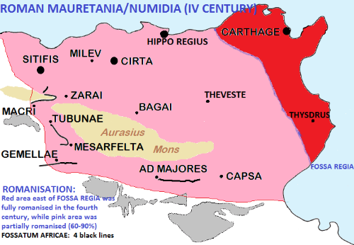
Romanization of Africa in 4th century CE
Red Latin, Pink 60 to 90% Latin


North African Roman Provinces
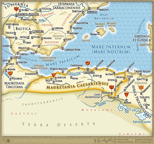
The province of Mauretania Caesariensis existed from 42 AD to the 7th Century. During and after the Fall of the Western Roman Empire in the 5th century, most of the hinterland area was lost, first to the Vandal Kingdom and later to the Mauro-Roman Kingdom, with Roman administration limited to the capital of Caesarea.
.
The land was reconquered by Rome during the reign of 
Justinian. In the late 580s, under the emperor Maurice, all of the Maghreb was granted to the Exarchate of Africa, and Mauretania Caesariensis became part of a new province, Mauretania Prima. The Muslim conquest of the Maghreb in the late 600s brought an end to Roman rule.
.
Over time the use of Latin would have moved closer and closer to the coast.

Arch of Caracalla (Triumphal Arch)
In 
Volubilis, Roman Morocco
The city fell to local tribes around 285 and was never retaken by Rome because of its remoteness and indefensibility on the south-western border of the Roman Empire. It continued to be inhabited for at least another 700 years, as a Latinised Christian community.  The Eastern Empire retained a small island of control on the Moroccan coast until the Arab conquest.

Roman Military Colonies

Latin speaking Roman Africans lived in all the coastal cities of contemporary TunisiaWestern LibyaAlgeria and Morocco.

The Roman Africans were generally local Berbers or Punics, but also the descendants of the populations that came directly from Rome itself or the diverse regions of the Empire as legionaries and senators.

The African province was amongst the wealthiest regions in the Empire (rivaled only by Egypt, Syria and Italy itself) and as a consequence people from all over the Empire migrated into the province. Large numbers of Roman Army veterans settled in Northwest Africa on farming plots promised for their military service.

Since the second half of the first century BC and as a result of increasing communities of Roman citizens living in the North African centers, Rome started to create colonies in North Africa.

  1. The main reason was to control the area with Roman citizens, who had been legionaries in many cases. 
  2. The second reason was to give land and urban properties to the Roman military troops who had fought for the Roman Empire and so decrease the demographic problem in the Italian peninsula
  3. The third reason was to facilitate the Romanization of the area and so the integration of the local Berbers -through marriage and other relationships- in the Roman Empire's social and cultural world.

Emperor Septimius Severus
From
 Leptis Magna in the Roman province of AfricaSeptimius Severus grew up in Leptis Magna. He spoke the local Punic language fluently, but he was also educated in Latin and Greek, which he spoke with a slight accent.


Under Theodosius the area east of the Fossa regia was fully Romanized with one third of the population made of Italian colonists and their descendants. The other two thirds were Romanized Berbers, who were all Christians and nearly all Latin speaking.

Called the "Granary of the Empire", Romano-berber North Africa produced one million tons of cereals each year, one-quarter of which was exported. Additional crops included beans, figs, grapes, and other fruits. By the second century, olive oil rivaled cereals as an export item. In addition to the cultivation of slaves, and the capture and transporting of exotic wild animals, the principal production and exports included the textiles, marble, wine, timber, livestock, pottery such as African Red Slip, and wool.

Berber Africa -from northern Morocco to Tripolitania- had a population of more than 3 million inhabitants in the third century.

Nearly 40% were living in more than 500 cities. But in the sixth century -after the Byzantine reconquest- the population was reduced to less than 2.5 millions and after the Arab conquest in the eighth to tenth centuries there remained only one million.

There were 20 cities in the territory of actual Tunisia with the title and privileges of "Roman Coloniae" or similar, while in Algeria there was nearly the same amount and in Morocco and Libya only a few. 
The most important was the "capital" new Carthago, with more than 300,000 inhabitants during Septimius Severus times (who enhanced Leptis Magna -where he was born- to be the second city of Berber Africa with nearly 100,000 inhabitants).  
The verified "Roman Coloniae" in Africa were:


 A mosaic on the floor ‘Labors of Hercules house’
in Volubilis, near Meknes, Morocco.

The End of Latin

The Muslim conquest of North Africa in the late 600s and early 700s did not end Latin. Local Latin speaking communities appear to have gone on for many centuries.

Spoken Latin is attested in the city of Gabès by Ibn Khordadbeh (died 912), in BéjaBiskraTlemcen and Niffis by al-Bakri (died 1094) and in Gafsa and Monastir by al-Idrisi (died 1165). 

The latter said of Gafsa that "its inhabitants are Berberised, and most of them speak the African Latin tongue."

The Normans, when they were acquiring their African kingdom in the 12th century, received help from the remaining Christian populations of Tunisia, and some historians argue that those Christians still spoke a Romance language.

The language existed until the arrival of the Banu Hilal Arabs in the 11th century and probably until the beginning of the fourteenth century. According to one historian, "Christian communities, generally labelled Afariqa or Ajam in the Arab sources and speaking a Latin dialect ... are known to have survived until the fourteenth century."

Virginie Prevost pinpointed that -between the Berbers of Afrikiya- the African Romance language was linked to Christianity, that survived in north Africa until the XIV century and according to the testimony of Mawlâ Aḥmad probably until the early XVIII century in Touzeur (south of Gafsa). 

The Arab Mawla Ahmad wrote that in 1709 "the inhabitants of Tazeur are what remains of the Christians who were once in Afrikiya, before the Arab conquest".


Click to enlarge
Languages of the Eastern Roman Empire

Portrait of the Roman African poet Terentius
Terentius may have been born in or near Carthage. He may have lived in the territory of the Libyan tribe called by the Romans Afri. 

Roman Emperor Heraclius
Heraclius brought an army from Latin speaking Carthage to Constantinople to overthrow the Emperor Phocas. He was crowned Caesar Flavius Heraclius Augustus in 610.


(Roman Africans)    (Languages)    (African Romance)

(Kingdom of Africa)    (Roman colonies)

Friday, November 2, 2018

The Fortress of Apollonia in Cyrenaica


The Byzantine Palace in Apollonia with the Eastern Basilica in the background. The previous use was as a Roman military commander's house.

Apollonia - African Military Base

  • As the capital of the Roman province of Libya Superior, the walled port of Apollonia would have been a military hub for the region. The army would keep the peace against inland tribal raiders while the navy would drop in for supplies while on patrol.


Apollonia in Cyrenaica (modern Libya) was founded by Greek colonists and became a significant commercial center in the southern Mediterranean. It served as the harbor of Cyrene, 20 km (12 mi) to the southwest.
An earthquake damaged the city in 365, but it survived, although many ancient buildings were destroyed. Nevertheless, Apollonia became more important than it had ever been, because in the fifth century, the interior was abandoned to the Libyan Laguatan nomads.
The port remained one of the last bases of Byzantine troops during the Muslim invasions.  There were several new building projects, like the easterncentral, and western basilicas.
The town, refortified during the Ananeosis ("renewal") but in the end conquered by the Arabs, was abandoned in the Middle Ages.
Apollonia became autonomous from Cyrene at latest by the time the area came within the power of Rome, when it was one of the five cities of the Libyan Pentapolis, growing in power until, in the 6th century A.D., it became the capital of the Roman province of Libya Superior or Libya Pentapolitana. 
The city became known as Sozusa, which explains the modern name of Marsa Susa or Susa, which grew up long after the cessation of urban life in the ancient city after the Arab invasion of AD 643.
The early foundation levels of the city of Apollonia are below sea level due to submergence in earthquakes, while the upper strata of the later Byzantine Christian periods are several meters above sea level, built on the accumulated deposits of previous periods.
The Palace was last used as the Byzantine Duke's Palace and contains over 100 rooms. The previous use was as a Roman military commander's house.
The well-preserved Greek theater stands facing the sea outside the old city walls. The cavea has 28 seat levels.

Apollonia was founded as the port of Cyrene. In case of an emergency, like the Arab invasions in the late 600s, the walls had to be defended. The walls of Apollonia, therefore, do not date back to the oldest stage of occupation, but were built in the Hellenistic Age. They are very well preserved, especially in the southeast.

Gate going to the central court of the palace.

The Palace of Apollonia

Apollonia was made capital of a newly created province, Libya Superior, by the emperor Diocletian (r.284-305). It was renamed Sosouza ("savioress"), probably after a goddess who was venerated here (Isis?). The military leader of the region, the dux, built his palace in the city, and rebuilt the original wall from the third century BCE, which was next to it.

The photo above shows one of the gates that gave access to the central court. As you can see, a cross was cut into the stone over this door: a memory of the Christianization of the Roman empire during the reign of Constantine the Great (r.306-337) and his son Constantius II (r.337-361). 

The palace once had two stories, but only the rooms on the ground floor - where the governor received his guests - remain. There were two large villas near this monument, which were probably used as an annex to the palace.

Apollonia became especially important in the fifth century, when the interior was abandoned to the Laguatan nomads (Synesius of Cyrene describes these disastrous years in his Catastasis). The port remained one of the last bases of the Byzantine troops and the palace of the dux must have been one of the most important military buildings in the Cyrenaica.

According to Procopius, the Byzantine Empress Theodora spent several years in the palace of Apollonia, as mistress of a governor named Hecebolus. Later, she married Justinian (527-565) and became one of the most powerful women from Antiquity.


Reconstruction of the port of Apollonia
(Livius)

The port of Apollonia was built around two or three natural harbors, which have disappeared beneath the waves in 365 CE, when a giant tidal wave destroyed the coast of northern Africa. It seems that the inner harbor - which was surrounded by quays and store houses - was used for warships, and the outer harbor for merchant ships. 

In the eastern part were a large mole and a lighthouse. This mole and the outer harbor were built by the Romans; the inner harbor appears to be Greek.

In 1987, a small ship (thirteen meters long) was discovered; the remains are now in the museum of Sousa.


Port facilities
Apollonia was an important port for commerce in North Africa. 

Apollonia, bathhouse and port
The Bathhouse

The Bathhouse was built during the reign of the emperor Hadrian (117-138). Probably, the court that is the core of the bathhouse is the peristyle of an older house: many Greek houses from the Hellenistic age were built around a garden-court (cf. the Villa of the Four Seasons Mosaic in Ptolemais and the Villa of Jason Magnus in Cyrene).

Today, you can still see the courtyard, which was once surrounded with Corinthian columns, and must have been used by people doing their athletic exercises (palaestra). Also visible are the real baths, which were still in use in the fourth century. The original entrance must have been to the north, where the main road of Apollonia used to be until, in 365, a large tidal wave destroyed much of the city. After that, the Baths were abandoned; it seems that people were living in the old monument.


Defensive city walls of Apollonia

Military and Civil Administration

Egypt was formed into a separate diocese in about 381. According to the Notitia Dignitatum, which for the Eastern part of the Empire dates to ca. 401, the diocese came under a vicarius of the praetorian prefecture of the East, with the title of praefectus augustalis, and included six provinces:
  • Aegyptus (western Nile delta), originally established in the early 4th century as Aegyptus Iovia, under a praeses
  • Augustamnica (eastern Nile delta), originally established in the early 4th century as Aegyptus Herculia, under a corrector
  • Arcadia (central), established ca. 397 and having previously briefly listed in the 320s as Aegyptus Mercuria, under a praeses
  • Thebais (southern), under a praeses
  • Libya Inferior or Libya Sicca, under a praeses
  • Libya Superior or Pentapolis, under a praeses

6th Century Eastern Roman Soldier

Parallel to the civil administration,
the Roman army in Egypt had been placed under a single general and military governor styled dux (dux Aegypti et Thebaidos utrarumque Libyarum) in the Tetrarchy
Shortly after the creation of Egypt as a separate diocese (between 384 and 391), the post evolved into the comes limitis Aegypti, who was directly responsible for Lower Egypt, while the subordinate dux Thebaidis was in charge of Upper Egypt (Thebais). 
In the middle of the 5th century, however, the latter was also promoted to the rank of comes (comes Thebaici limitis). The two officers were responsible for the limitanei (border garrison) troops stationed in the province, while until the time of Anastasius I the comitatenses field army came under the command of the magister militum per Orientem, and the palatini (guards) under the two magistri militum praesentales in Constantinople.
The comes limitis Aegypti enjoyed great power and influence in the diocese, rivalling that of the praefectus augustalis himself. From the 5th century, the comes is attested as exercising some civilian duties as well, and from 470 on, the offices of comes and praefectus augustalis were sometimes combined in a single person.
This tendency to unite civil and military authority was formalized by Justinian I in his 539 reform of Egyptian administration. The diocese was effectively abolished, and regional ducates established, where the presiding dux et augustalis was placed above the combined civil and military authority:
  • dux et augustalis Aegypti, controlling Aegyptus I and Aegyptus II
  • dux et augustalis Thebaidis, controlling Thebais superior and Thebais inferior
  • Augustamnica I and Augustamnica II were likewise probably — the relevant portion of the edict is defective — were placed under a single dux et augustalis
  • in the two Libyan provinces, the civil governors were subordinated to the respective dux
  • Arcadia remained under its praeses, probably subordinated to the dux et augustalis Thebaidos, and a dux et augustalis Arcadiae does not appear until after the Persian occupation of 619–629.


Apollonia, central basilica, baptistery

Apollonia, central basilica

Apollonia, east basilica, mosaics

Apollonia in Cyrenaica (eastern Libya) after Alexander


From Megas Alexandros

In 322 BC, the year after Alexander’s death, Ptolemy I who had established himself as ruler of Egypt conquered five Libyan cities. They are collectively known as thePentapolis and include beside Cyrene, the cities of Apollonia, Ptolemais or Barca,Arsinoe or Taucheira (modern Tocra) and Euesperides or Berenice (near modern Benghazi). In those days, Cyrenaica was part of greater Egypt and often simply assimilated to Egypt itself. 

The region was very fertile and produced wheat and barley, as well as olive oil and wine; the orchards in turn were filled with fig and apple-trees; sheep and cattle roamed widely; and above all, this was the only place in the world where silphium grew, a natural medicine, a contraceptive and aphrodisiac.


In an earlier post, I already wrote about Cyrene (see: Cyrene, founded by the Greeks), so this time I’ll concentrate onApollonia, now renamed Susa in today’s eastern Libya, the most obvious choice since it was the harbor for majestic Cyrene only some twenty kilometers further inland.

Apollonia was founded by Greek colonists as early as the 7th century BC and during the fourth century BC the harbor facilities were widely improved, sheltering the berths against the strong northern winds. On the west side a new inland port was constructed, protected by two towers while on the most eastern island a lighthouse was installed. It was only in the first century BC that Apollonia became a city in its own right. Not for long, however, since upon Ptolemy III’s death in 96 BC the entirePentapolis, including Cyrene and Apollonia was bequeathed to the Romans who just moved a step closer to Egypt itself …

Apollonia was part of The Diocese of Egypt which was a diocese of the later Roman Empire (from 395 the Eastern Roman Empire), incorporating the provinces of Egypt and Cyrenaica. Its capital was at Alexandria, and its governor had the unique title of praefectus augustalis ("Augustal Prefect", of the rank vir spectabilis; previously the governor of the imperial 'crown domain' province Egypt) instead of the ordinary vicarius. The diocese was initially part of the Diocese of the East, but in ca. 380, it became a separate entity, which lasted until its territories were finally overrun by the Muslim conquest of Egypt in the 640s.


Today’s visitor to Apollonia will only find half of the antique city as the other half lies under water. Northern Africa has suffered badly from a devastating earthquake that occurred in 365 AD, causing the entire coastline to drop by four meters. The phenomena is clearly visible here in Apollonia where the old harbor is entirely drowned and the three off-shore islands is all that remains of the northern pier. This explains why the city doesn’t have the appeal of a harbor, and certainly not one to serve a city as important as Cyrene. Apparently shipwrecks from the fourth century BC have been located in the antique harbor where French archeologists were diving during my visit in 2010. I hate to think about what has happened since.

Anyway, Apollonia’s remains are mainly Byzantine, with three Basilicas: the western Basilica with three naves; the central Basilica with five naves; and to the far end the eastern Basilica, the largest, from the 6th century with an exceptional Baptistery because it counts six steps instead of the normal three. My local guide tells me that in the Byzantine era the purpose of this Baptistery was not to baptize people in order to convert them but to receive forgiveness for their sins. One submersion would cleanse the believer from small sins, but for more serious offenses five or six submersions would be required. I never heard of this theory but it may be a logical explanation for the great number of baptisteries in these churches.

Next to the central Basilica are the remains of a Roman Bath, whose lay-out, except for the entrance gate, is rather confusing. That is no surprise when you think how the Byzantines liked to re-model Roman buildings or re-use their stones elsewhere.

Alongside the Byzantine city wall and approximately across from the Roman Baths, lies the Palace of the Dux, the Byzantine governor Hekobolius from the 6th century, i.e. the time when Apollonia was the capital of the Pentapolis. The palace itself has not much to offer but the story that goes with it is rather interesting. For nearly six years, this Hekobolius kept an extremely good looking mistress called Theodora. One day she happened to be dancing in Constantinople for Emperor Justinian who fell in love head over heels and married her soon after. This is how Empress Theodora arrived at the imperial court where she lived happily ever after … Well, this marriage lasted about twenty years and Theodora died before Justinian, on 28 June 548.

There are more remains of Apollonia that have not yet been excavated, including the Acropolis at the far end of the site. Outside the city-wall lies the inevitable Roman theater (although built on an earlier Greek one) that now lies near the shoreline. According to an inscription found near the podium, it was built in 92 AD during the reign of Emperor Diocletian. This is the best preserved theater of theCyrenaica in spite being used as a quarry by the Byzantines.

A last glance over Apollonia makes me realize that the restored columns of the different Basilicas are the most notable features, but that is primarily because of their texture. All these columns are made of cipolin marble, imported from the islandof Euboea before the coast of easternGreeceCipolin is the Italian name for onions and is used to describe this kind of marble which, like onion skins, appears in green-greyish streaks – a very appropriate name, I must say.

Walking back along the coastline, my attention is drawn towards four large round pits carved in the rock. These pits were used to marinate fish in order to make the famous garum or fish paste, a delicacy for the Romans. How interesting!

The well-preserved Greek theater stands facing the sea outside the old city walls. The cavea has 28 seat levels.

Byzantine Church in Apollonia by the coast.

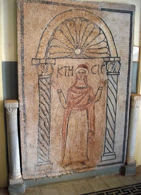
The Goddess Ktisis
The personification of generosity and donation, of Libyan Isis: the Goddess of Agriculture.

(Apollonia (Susa) Museum)


(Apollonia)      (Diocese of Egypt)      (temehu)      (makedonia-alexandros)

(Google books)     (apollonia-photos)      (apollonia-baths)      (Livius.org Libya)


Monday, August 7, 2017

Roman Fortress of Taucheira, Libya


Old entrance of Taucheira (Torca) from a later period.
(Wikimedia.org)

Roman Libya


After the final conquest and destruction of Carthage in 146 BC, northwestern Africa went under Roman rule and, shortly thereafter, the coastal area of what is now western Libya was established as a province under the name of Tripolitania with Leptis Magna capital and the major trading port in the region.

In 96 BC Rome peacefully obtained Cyrenaica formed by the cities of Cyrene, its port of ApolloniaArsinoe (Taucheira - Tocra), Berenice (near modern Benghazi) and Barce. 

In 74 BC was established the new province, governed by a legate of praetorian rank (Legatus pro praetor) and accompanied by a quaestor (quaestor pro praetor). But in 20 BC Cyrenaica was united to the island of Crete in the new province of Creta et Cyrenaica, because of the common Greek heritage.

During the first two centuries nomadic raids from the desert were a regular occurrence.

The first desert fort on the limes was built at Thiges, to protect from nomad attacks in 75 AD. The limes was expanded under emperors Hadrian and Septimius Severus, in particular under the legatus Quintus Anicius Faustus in 197-201 AD.


Anicius Faustus was appointed legatus of the Legio III Augusta and built several defensive forts of the Limes Tripolitanus in Tripolitania in order to protect the province from the raids of nomadic tribes. 

Former soldiers were settled in this area, and the arid land was developed. Dams and cisterns were built in the Wadi Ghirza to regulate the flash floods.  

The farmers produced cereals, figs, vines, olives, pulses, almonds, dates, and perhaps melons. Ghirza consisted of some forty buildings, including six fortified farms (Centenaria).

But Jewish revolts were a far greater concern to the central government. A serious Jewish revolt was in the time of Trajan (in 115-116 AD).

The 4th century Christian historian Paulus Orosius records that the violence so depopulated the province of Cyrenaica that new colonies had to be established by Hadrian:
"The Jews ... waged war on the inhabitants throughout Libya in the most savage fashion, and to such an extent was the country wasted that, its cultivators having been slain, its land would have remained utterly depopulated, had not the Emperor Hadrian gathered settlers from other places and sent them thither, for the inhabitants had been wiped out."
By 203 the entire southern frontier of Roman Africa had been dramatically expanded and re-fortified. Desert nomads could no longer safely raid the region's interior and escape back into the Sahara. 

Roman Libya slowly declined in importance and became something of a backwater area to both Rome and Constantinople. 

Cyrenaica was split into two provinces: "Libya Superior" and "Libya Inferior".  Each was under a governor of the modest rank of praeses. Both belonged to the Diocese of Egypt, within the Praetorian prefecture of Oriens.

In April 534 AD, the old Roman provincial system along with the full apparatus of Roman administration was restored, under a praetorian prefect.  Roman rule in Libya was strengthened, but the fighting continued against the Berber tribes of the Sahara.

The province entered an era of relative stability and prosperity, and was organized as a separate exarchate in 584 AD. Eventually, under Heraclius, Libia and Africa would come to the rescue of the Empire itself, deposing the tyrant Phocas and beating back the Sassanids and the Avars.

But that was the last Roman achievement: in 642 AD Moslem Arabs started to conquer Libya. In 670 AD all Libya was in the hands of the Arabs. Roman Libya was no more.

The coastal Fortress of Taucheira was in the province of Libya Superior. For administration it was part of the Diocese of Egypt until 539 AD. Then it came under the Diocese of the East.
.
The entire area was occupied by invading Persian armies in the 610s and 620s, during the Byzantine–Sassanid War of 602–628

Plan of early medieval Taucheira (Torca). 
Supplied by sea, the fortress held out for years against invading Muslim armies.

Defending Roman North Africa

The Roman Fortress of Taucheira in Libya has almost totally vanished, but in its time it was a major military project of the Emperor Justinian (r. 527 - 565).

With the Roman Re-Conquest of North Africa the Emperor went on an African building spree from the Pillars of Hercules to eastern Libya.  Fortifications were being built from scratch or re-built on top of existing structures.  Justinian also created the new Limes Tripolitanus system of forts to protect the Roman coastal zone from invasion by desert tribes.

Justinian's fortifications were a clear signal to the world that Rome was back in Africa to stay.

The Fortress of Taucheira is a good example of that we here to stay spirit.

Of course, Taucheira always had city walls. They were renewed on several occasions. An inscription in the little museum of Taucheira commemorates a man named Aleximachus son of Sostratus, who had provided the money to improve the walls of the city somewhere in the first century BC.

But Justinian wanted something impressive.

Except for the stretch along the shore, the lower parts of it have survived. It must have have had about thirty towers, of which twenty-three have been excavated. Older stones were reused, like the one with an inscription on which the words Autokrator Kaisar can still be read, the Greek translation of the Latin titles Imperator and Caesar.

The massive walls of Taucheira/Arsinoe enabled the Byzantine commander Apollonius, when besieged by the Muslim forces who had invaded the Cyrenaica in 641, to hold out until 645.

This siege, of which we know next to zero, is yet another untold story of the Eastern Roman military. Obviously there were enough troops there to man the rather considerable city walls. Was the garrison re-supplied by sea from Constantinople or Italy? We do not know.

Excavations at Taucheira provide a glimpse of a coastal Cyrenaican town after the Arab conquests.  Digs have found buildings centered on two courtyards, and a bath complex.

The baths had the two plunge baths either side of the furnace and the use of stone uprights instead of the usual Roman brick pilae.  The street-plan is somewhat irregular, with winding streets and alleys that lead into the houses.

Byzantine fortress inside the city

Taucheira, main road, to the northeast

.
North Africa
From Alexandria to the Pillars of Hercules


By Procopius of Caesarea
500 - 554 AD

The Buildings

But inasmuch as our account has now led us to Egypt, the close neighbour of Libya, let us now set forth how many things were done by him there also, since this Emperor found all Libya too lying under the power of barbarians and joined it to the remainder of the Roman Empire.

And the land on the left of the Nile bears the name of Libya as far as the Ocean, which on the west marks the boundary between the two continents by sending out a certain arm which opens out into this sea of ours.  All the rest of Libya has received several different names, each region being designated, presumably, by the name of the people who dwell there.  

However, the territory extending from the confines of Alexandria as far as the cities of Cyrenê, comprising the Pentapolis, is now the only region which is called by the name of Libya.  In that territory is a city one day's journey distant from Alexandria, Taphosiris by name, where they say that the god of the Egyptians, Osiris, was buried.  In this city the Emperor Justinian built many things, and in particular the residences of the magistrates and baths.

The greatest part of this land of Libya chances to have been desert, which was in general neglected.  Yet our Emperor takes thought for this land also with watchful care, so that it might not have the ill fortune to suffer anything from inroads of the Moors who inhabit the adjoining country; and to this end he established there two strongholds with garrisons, one of which they call Paratonium, while the other,   which lies not far from the Pentapolis, has received the name Antipyrgum.  


Port facilities of Taucheira

And the Pentapolis is removed from Alexandria by a twenty days' journey for an unencumbered traveller. In this region of Pentapolis the Emperor Justinian surrounded the city of Teuchira with very strong fortifications.  The circuit-wall of Bernicê he rebuilt from its lowest foundations.  In that city he also built a bath for the use of the people.  Furthermore, on the extreme boundary of the Pentapolis which faces the south, he constructed fortresses in two monasteries which bear the names Agriolodê and Dinarthisum;  and these stand as bulwarks against the barbarians of that region, so that they may not come down stealthily into Roman territory and suddenly fall upon it.

There is a certain city there, Ptolemaïs by name, which in ancient times had been prosperous and populous, but as time went on it had come to be almost deserted owing to extreme scarcity of water.  For the great majority of the population, driven by thirst, had moved from there long ago and gone wherever each one could.  

Now, however, this Emperor has restored the city's aqueduct and thus brought back to it its former measure of prosperity. The last city of Pentapolis towards the west is named Boreium. Here the mountains press close upon one another, and thus forming a barrier by their crowding, effectively close the entrance to the enemy.  This city, which had been without a wall, the Emperor enclosed with very strong defences, thus making it 
as safe as possible for the future, together with the whole country round about it.

And there are two cities which are known by the same name, each of them being called Augila. These are distant from Boreium about four days' journey for an unencumbered traveller, and to the south of it; and they are both ancient cities whose inhabitants have preserved the practices of antiquity, for they all were suffering from the disease of polytheism even up to my day.  There from ancient times there have been shrines dedicated to Ammon and to Alexander the Macedonian.  The natives actually used to make sacrifices to them even up to the reign of Justinian.  In this place there was a great throng of those called temple-slaves. 

Taucheira Church mosaic

But now the Emperor has made provision, not alone for the safety of the persons of his subjects, but he has also made it his concern to save their souls, be thus he has cared in every way for the people living there.  Indeed he by no means neglected to take thought for their material interests in an exceptional way, and also he has taught them the doctrine of the true faith, making the whole population Christians and bringing about a transformation of their polluted ancestral customs.  Moreover he built for them a Church of the Mother of God to be a guardian of the safety of the cities and of the true faith. So much, then, for this.

The city of Boreium, which lies near the barbarian Moors, has never been subject to tribute up to the present time, nor have any collectors of tribute or   taxes come to it since the creation of man.  The Jews had lived close by from ancient times, and they had an ancient temple there also, which they revered and honoured especially, since it was built, as they say, by Solomon, while he was ruling over the Hebrew nation.  But the Emperor Justinian brought it about that all these too changed their ancestral worship and have become Christians, and he transformed their temple into a church.

Next after this comes the city of Leptis Magna, which in ancient times was large and populous, though at a later time it came to be deserted for the most part, being through neglect largely buried in sand.  Our Emperor built up the circuit-wall of this city from the foundations, not however on as large a scale as it was formerly, but much smaller, in order  that the city might not again be weak because of its very size, and liable to capture by the enemy, and also be exposed to the sand.  

At present, indeed, he has left the buried portion of the city just as it was, covered by the sand heaped up in mounds, but the rest of the city he has surrounded with a very strongly built wall.  Here he dedicated to the Mother of God a very notable shrine, and built four other churches.  Furthermore, he rebuilt the palace, which had been built here in early times and now lay in ruins, the work of the ancient Emperor Severus, who was born in this place and so left this palace as a memorial of his good fortune.

In this city the Emperor Justinian also built public baths, and he erected the circuit-wall of the city from its lowest foundations, and by means both of the baths and of all the other improvements gave it the character of a city.

The east wall of the Taucheira fortress

Southwest gate

Taucheira, East Basilica
(Livius.org)


(Procopius)      (Medieval North Africa 650-800)      (Taucheira)

(Livius)      (Tocra)      (Crete and Cyrenaica)      (Cyrenaica)      (Tocra)